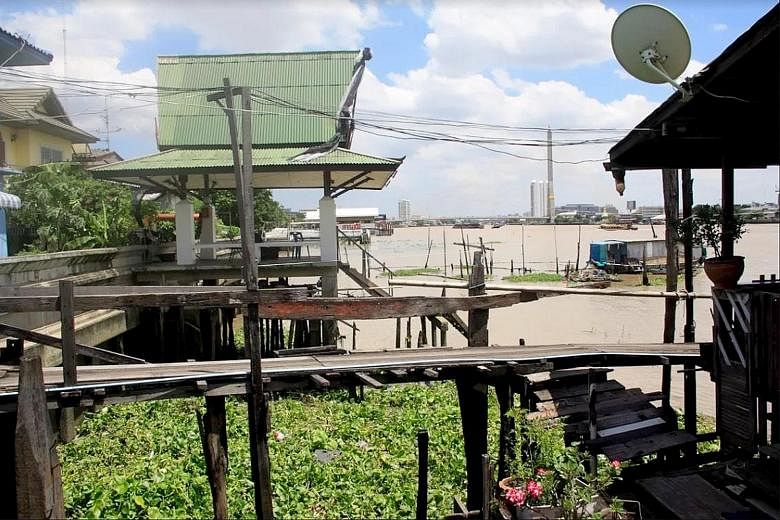
At the foot of Rama VII Bridge north of the Chao Phraya River is a big Thai restaurant called O-Yua River Terrace with an open-air area that extends over the brown murky waters.
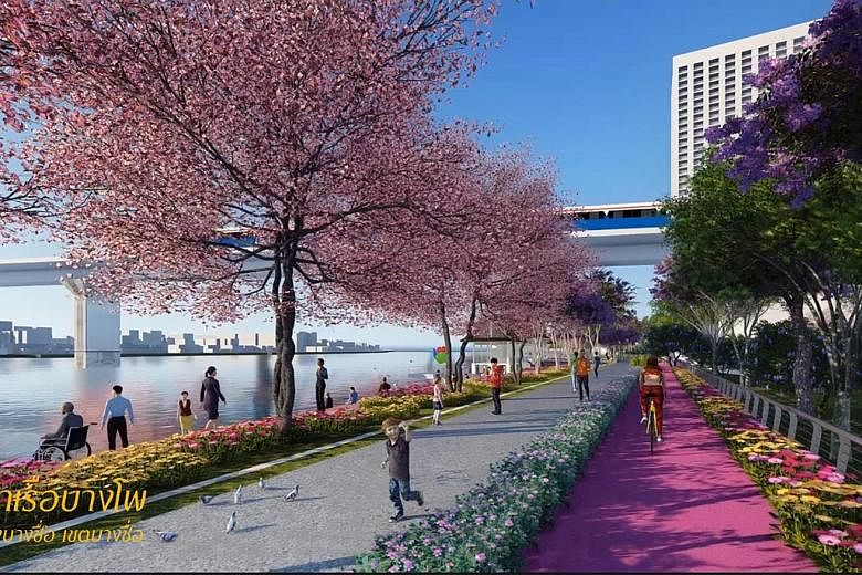
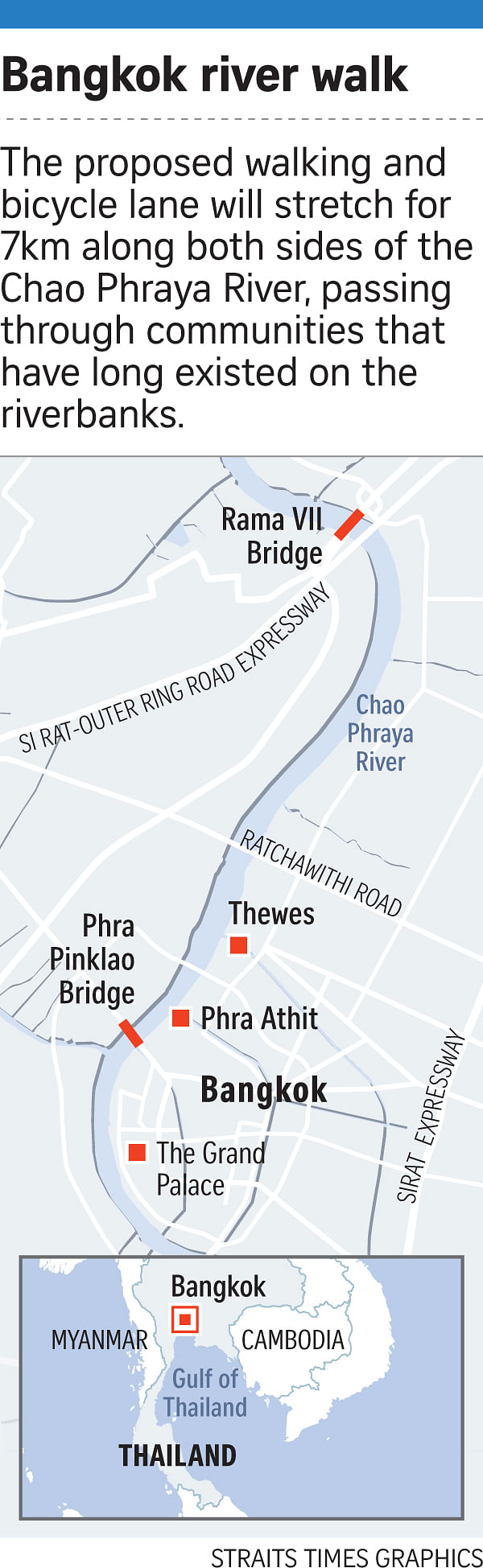
This marks the starting point for a new walking and bicycle lane, tentatively slated to begin construction next month, stretching 7km southwards - on both sides of the river - until the Phra Pinklao Bridge.
The route, which measures the width of a three-lane road, will pass through well-known areas including Phra Athit, where many offices of international organisations such as Unicef are located. It will be built on concrete platforms and supported by stilts, and will jut out 10m on each side of the river.
The government will uproot some communities living along the riverbank to make way for the lane, in the first phase of the multi-billion-baht Chao Phraya Riverside Promenade Project by the Bangkok Metropolitan Administration (BMA). The government hopes the lane will become a new tourist magnet.
The riverbank communities include Mitrakam in the city's old district, where Mrs Jamnian Paungrayha, 54, lives with her three sons, three grandsons and 10 birds in a wooden house supported by stilts. The 64 sq m house has four bedrooms, a luxury by Bangkok standards.
Mrs Jamnian claims her late father has been living in Mitrakam since World War II. But now she has to take her family of six plus the birds elsewhere to make way for the lane, which is about 11.4km from the main pier in Saphan Thaksin. The area the government picked for the initial phase of construction is quieter and far from the city's main tourist attractions and the big hotels and restaurants.
Currently, it takes 22 minutes by boat to travel from Phra Pinklao Bridge to Rama VII Bridge.
Walking would take about an hour-and-a-half or longer, via meandering pathways of the riverbank settlements inland.
-
About the project
-
Chao Phraya River is 375km long and flows from Nakonsawan province to the Gulf of Thailand in Samut Prakarn province. Its width ranges from 200m to 1,200m.
The river that flows to the khlongs (canals) earned Bangkok the name "Venice of the East". It is an important waterway and draws tourists and locals. Boats transport passengers to 31 piers.
The proposed walking and bicycle lane will eat up 10m on both sides of the river and is the first phase in the ambitious Chao Phraya Riverside Promenade Project. It covers a distance of 7km, from Phra Pinklao Bridge all the way north to Rama VII Bridge.
According to a proposed plan, the lane will be constructed out of concrete structural platforms, resembling a highway structure. The original embankment level will be raised by 0.45m and will be 3.25m above sea level.
The lane will pass through residential communities, commercial areas, and educational, governmental and religious institutions.
The construction of the embankment will hide from view some important landmarks like palaces and temples that are part of Chao Phraya's cultural landscape.
Critics fear the lane will narrow the passageway where boats and barges regularly pass. They also cite environmental issues, such as flooding and blocked water flow that may result in waste and putrid water being trapped.
The project would spoil the view of the river from land, and destroy privacy for residents living along the banks, they added.
Chao Phraya, which draws tourists day and night, is an important transport route for locals and the government believes the promenade project will make the riverside even more accessible, attractive and convenient for everyone. Still, the lane's construction has been pushed back many times due to controversies.
Opponents have warned that the proposed new lane is poorly planned and lacks consultation, leaving a lot of uncertainty for communities and businesses.
Mitrakam, only one of 33 communities that will be affected, used to be a giant floating market before transforming into a settlement.
While the birds and their cages are easily movable, it is much harder for Mrs Jamnian's family to uproot themselves because they have established their life along the river for many decades.
She sells food at a school nearby while her children study or work around the area too. "Moving house is a problem because I have to start all over again," she said.
According to Mrs Jamnian, government representatives have come to talk to residents and given them two options: move to government housing under a 20-year payment scheme or receive a remuneration of 5,000 baht (S$203) per sq m. She has opted to take the money because the allocated government housing is located in Nonthaburi province, 10km north of Bangkok, which she described as a "forest".
The government started demolition of 14 riverside communities last Saturday and expects to finish the task by the end of this month.
However, her neighbour Somnuch Suthiwong, 68, refuses to move if he has a choice. He has lived along the river since he was born.
"How can I pay for a house for 20 years? I will be dead by then," he said.
Previous administrations have attempted but failed to successfully initiate a riverside promenade. However, the junta, under Prime Minister Prayut Chan-o-cha, appears to be determined to push it through despite criticism and opposition.
"Twenty years ago, they wanted to build a road along the river," said Mr Pornsan Vichienpradit, deputy director of the Urban Design and Development Centre (UDDC).
He said the idea was revived in late 2014, a few months after the junta took over the government, but the plan has since been converted into a walking and bicycle lane, and the width reduced from 20m to 10m on each side. The reduction was seen as a compromise with opponents who were worried that the promenade will destroy the riverside's environment and cultural heritage.
"The river will be very narrow and it will be difficult for boats to travel," said Ms Raweewan Samitaman, 40, a self-employed resident of Ban Poon, another affected community located near the Rama VIII bridge.
She said it would also affect the city's cultural aspects, including the elaborate Royal Barge Procession, a tradition of over 700 years. The procession involves 52 barges and proceeds down the Chao Phraya River up to the Grand Palace. The last time it was held was in 2012 when King Bhumibol Adulyadej was still alive.
The construction of the lane would have an impact on traditional river events like this since it would narrow Chao Phraya's width, Ms Raweewan said.
"If they need to build on land, we can move for them," she added. "Just don't build on the river."
Many residents in Ban Poon had to move in 1999 when the Rama VIII bridge was constructed. This time, the remaining residents have to contend with the possibility of a higher embankment that may obstruct the flow of water and cause floods in their community instead.
Ms Raweewan said that the plan changes constantly and the government has failed to provide adequate information to the communities.
Businesses along the river have also complained about this.
"To be honest, we are not very clear about the project either," Ms Jularat Ouepanarangsi, director of sales and marketing at the Riva Hotel Group, said. "If it's for people to walk along the river, it's acceptable. But if it takes more space, it's bad not only from a business point of view but as a Thai."
Riva Surya hotel is located 1.3km from Phra Pinklao Bridge or about 15 minutes away on foot.
Ms Jularat said the government can use the walkway in front of the Millennium Hilton Bangkok and The Peninsula - farther down the river and not affected by the first phase - as models instead of following other countries without considering geography and history.
The government had said earlier the lane was inspired by similar projects in Yokohama, Japan, and Wisconsin in the United States.
"The idea is good but the implementation is difficult," UDDC's Mr Pornsan said. He noted that the riverbanks have different land uses and some are privately owned, thus the lane may not be a universal solution for all stakeholders.
But Ms Jip Hunsa, team leader of BMA's infrastructure division, said the government has followed the legal process, including impact assessment and consultations with affected communities.
"The study has been completed and we are in the process of estimating the cost. After finishing it, BMA will carry out the procurement process," Ms Jip told The Straits Times. She said construction will start later this year.
While the government has conducted three sessions with stakeholders, Mr Yossapon Boonsom, co-founder of Friends of River, said they merely canvassed opinions but there was no exchange of views.
Mr Yossapon also criticised a study conducted by King Mongkut's Institute of Technology Ladkrabang and Khon Kaen University over seven months that found the project will not have "that much" of an impact on people.
"It's a superficial study," he said. "It is better for the government to put this on hold. People are more worried about other things, a walkway along the river is the least of their concerns right now."
Mr Saifon Poochomsri, 50, manager of O-Yua River Terrace restaurant, wonders how the riverside will look once the lane is constructed, and whether their outdoor space will be reduced or completely phased out. This could mean a change in name too as there will no longer be a terrace for their customers to enjoy the scenery and the breeze from the river.
"I don't think it's a good idea, it will only narrow the river and block the scenery and view," he said. "Will it even make the tourists come?"